Majed Bouchahma
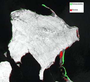
Coastal zones are exposed to a series of natural processes that usually causes changes in long and short time spans. Examples of these processes include coastal erosion, sediment transport, environmental pollution, and coastal development. While progress has been made in isolating and understanding individual processes influencing coastal change substantial research, nevertheless, remains to be done on understanding the advance and retreat dynamics of shorelines in the spatial and temporal domains. Given the compelling demand to develop efficient, integrative, and innovative approaches to investigate shoreline changes, this thesis focused on the development of geographical information systems (GIS)-based approach to analyze, model, and predict spatial locations along the Djerba Island coast that will either erosion or accretion. The unique strength of this approach is that it incorporates images processing techniques, empirical and remotely sensed derived data into a GIS to analyze, model, measure, predict and visualize shoreline changes. The empirical data represent one of the longest time series (1984–2009) of Djerba’s Shoreline change data, and the remotely sensed data are from a total of eight Landsat Thematic Mapper (TM) images. This research presents an automatic framework which can be applied at any study area and with any kind of remote sensing data. A pre-processing phase based on image processing techniques can detect automatically the study region, then the methodology process it will be applied on the resulted image to detect and measure the changes. Also in the absence of empirical data this research facilitates evaluating and predicting erosion and accretion of the shoreline with data incorporated into geographical information systems.The scope and objective of any scientific study will be rewarded only on the effective utilization of the obtained results by the end users. In-order-to attain this specific task, the obtained results are delivered through a web based framework to publish the spatial and non-spatial data including maps and meta data. Thus the present study will be very useful to research and developments, policy making purposes, resource management and environmental protection.- Bouchahma, M., & Yan, W. (2013). Monitoring shoreline change on Djerba Island using GIS and multi-temporal satellite data. Arabian Journal of Geosciences. https://doi.org/10.1007/s12517-013-1052-9
-
Bouchahma, M. M., Yan, W., & Ouessar, M. M. (2012). Island Coastline Change Detection Based on Image Processing and Remote Sensing. Computer and Information Science, 5(3), 27–36. https://doi.org/10.5539/cis.v5n3p27